
These landscape articles come from the Fyfield and West Overton Parish landscape group. We are an informal group made up of anyone who is interested and always keen to hear your comments. If you would like to join us you would be very welcome. Meetings take place round the kitchen table with a glass of wine! Some years ago we were the first parish in Kennet district to get up a village design statement. That project opened our eyes to the history we see every day in the buildings around us and made us think ” why only the buildings ?” Here we have a landscape etched over and over with the patterns of previous lives. We live in an Area of Outstanding Natural Beauty but we hardly ever think how it got that way. Most of us see it through a windscreen, unlike our forefathers who worked the land, but we all love it and want to protect it. These magazine articles are a way of thinking aloud about what we value.
 As well as hosting a roman road, during the Saxon and Medieval periods the present network of lanes evolved. These wound from settlement to settlement, often along river valleys. The King’s Special Peace was granted to the main crossing streets in villages and market towns during the 11th Century. On a map by Cary in 1787 the Bath Road is shown clearly to the north of the Kennet with a junction leading to Fyfield and routes on to Lockeridge from where routes branch to West Overton, and Alton Barnes in much the same manner as they do today. In 1792 roads are shown leading from both Lockeridge and Fyfield to Clatford, and George Lane in West Overton appears crossing the Kennet to join the main road. The road from West Overton crossing the river to the Bell is shown on Greenwood’s map in 1820. Some of these roads are now only footpaths e.g. footpath 16 from Lockeridge to Fyfield having been super-ceded by a new road from Lockeridge to the housing development at Priest Acre and a new junction with the A4 in the 1930’s.
Footpaths and Bridleways
Footpaths and bridleways – public rights of way – have evolved over not just hundreds but thousands of years. Prehistoric tracks and paths would have been formed by herds of migrating animals. They would have taken the easiest routes, with due regard to forage and water, and these in turn would have been followed by the earliest human inhabitants, hunter-gatherers. These routes gradually became established paths, the chalk ridgeways being among the first of these. The boundaries of the Saxon estates described in the 10th Century land charters probably followed pre-existing drove roads, many of them going back centuries before that, and very likely marking the limits of even earlier estates. These ways continued in use when the Saxon estates were replaced by medieval tithings and now by our civil parishes. Many of the old boundaries are gone but their lines can be traced in our highways, byways, footpaths and bridleways. Bridleway 20 (Spud Lane) connects Lockeridge Green with the West Woods along a tunnel of old hedge. This was once the boundary between old East Overton and the estate of the Knights Templar at Lockeridge.
The Romans brought with them organised road building, and some of their roads which fell into disuse have also become byways. Other routes were taken over or made by the Saxons which still exist today, for example, the Herepath or Green Street, between the northern edge of Marlborough and Avebury, now labelled as bridleway 5. Herepath refers to a military way. We cannot tell whether the route was really used as such in Saxon times or whether they gave it the name because of the legends that preceded them. It is certainly much older, it leads directly to Avebury. It served as the old Bath Road over Fyfield and Overton Downs. This is the route taken by Samuel Pepys in 1668 “with some trouble for being out of our way over the downes where the life of the shepherds is in fair weather pretty”. Looking west towards the Ridgeway from below the Delling a succession of deep ruts shows where carts and carriages laboured over the incline. Traffic returned to the route of the old Roman road with the arrival of turnpikes during the 18th century.
From late Saxon times until the Norman Conquest there was a network of roads and paths adequate for national purposes, to which little would have been added until the days of turnpikes and enclosures. In 1555 an Act of Parliament made each Parish responsible for the maintenance of highways within its boundaries, but for the next 300 years very few repairs were carried out, except to main roads. Tracks and byways remained very much the same, though many changed from cart ways to footpaths to bridleways.
In those far off times when global warming led to the first trickling away of the permafrost and the stripling river Kennet turned East instead of West, it established an important East-West corridor across the country. The North-South routes were just as important, however, as the earliest inhabitants turned to herding and farming. Flocks and herds were moved in a cycle from winter to summer pastures. There are threads of the drove roads still running through the landscape, some are forgotten, others still used, one such from the withy beds in West Overton across the river and then the main road by Grey Wethers, up the bank to the footpath which follows the boundary hedge between East and West Overton. So far the way is clear, but beyond Down Barn, on the open downlands to the North, there are only signs of the old drove road among the lumps and bumps of ancient field systems, if you know where to look. In the opposite direction, the route continues. Bridleway 19 (West Overton) marks the boundary between old West Overton and East Overton. Leaving the river to the north it skirts the withy beds and continues south along Frog Lane and Knights Close before crossing the down and descending to the Alton Barnes road. Then it continues uphill to the West Woods. Along its route is the primitive sarsen bridge in the withy beds and the Meux estate boundary stone marked HM near the West Woods where the bridleway still divides land holdings.
Notice, too, that section of bridleway 24 in West Woods, as it climbs to the south, away from the main forest track in the valley floor. To the side of it, there are the holloways made by earlier travellers repeatedly avoiding the mud, just as we do today, if we can.
Footpath 11 (Fyfield) follows the boundary between the modern civil parishes of Fyfield and Clatford. From north to south it links the West Woods with Clatford bottom west of the Devil’s Den crossing the river and the A4 on the way. Before 1905 this was the route to work tramped by the men working for stonemason Cartwright of Fyfield employed to cut sarsen in Temple Bottom and Wick Bottom.
Today the more famous and lasting of the North-South routes is the Ridgeway, byway 1, hardly needing a description, for surely all people from our villages have trodden its length at least once. Maybe it is one of the oldest roads in the country. Again it served as a boundary for the land-holdings from Saxon times and in all likelihood earlier. It served too as a herepath, for the Anglo Saxon Chronicle records that in 1006 the Vikings came down the Ridgeway to be met by Saxons at the battle, or skirmish, of East Kennett ford.
Sources include
The Development of the Public Rights of Way Network by Mrs. D. Chandler, Rights of Way Officer, WCC.
The Land of Lettice Sweetapple by Peter Fowler and Ian Blackwell, ISBN 07524-1415-1.
Roads and Tracks of Britain by Christopher Taylor, ISBN 1-85797-340-2.
The highways today
As we travel along the highways in this parish it is noticeable that they fall into two main categories ‘open’ and ‘enclosed’ be they busy or quiet.
The ‘open’ roads are by and large on the higher ground, with low or no hedges at all. So that travelling through the countryside with the sky in your lap, and open vistas of rolling grass and arable land, distant tree clumps or belts, the feeling is, of space, emptiness and washed out colour.
The meadow lanes in the river corridor with their bridges and railings, glimpses of river or flood water, moor hens and swans or grazing sheep, have a neat manicured feel.
The ‘enclosed’ roads are the highways and lanes tunnelled by overarching trees, hedges and ivy. Raucously active in early spring, dappled and green in early summer, cool dark and quiet by late summer, with seasonal falls of twigs, bird droppings, conkers, beech mast and leaves.
The sweet smell of summer comes to all our roads with the Hawthorn and Cow Parsley adorning every length of verge and hedgerow, followed by Mallow and finally the waving waist high dry grasses and hedgerow berries, shining against deep blue skies. Later skeletal trees and clipped hedges increase the bleakness of the winter landscape.
CONCERNS:
Too many traffic signs, concrete curb stones and black and white marker posts etc detract from the rural setting.
Unsympathetic timing for cutting of verges and hedges lead to loss of wild flowers and birds.
Larger vehicles make passing difficult on narrow roads leads to erosion of verges.
Visit www.upperkennetnews.co.uk and see the photos and maps to go with these articles, plus all the other Landscape Group articles and give us your comments.
Light is enshrined deep in our consciousness and our language as a thing to be sought. It stands in metaphor for safety, knowledge and spiritual salvation. No wonder it is such a latecomer to the list of statutory nuisances. Meanwhile moonlight fades in landscapes of permanant half light. The stars are going out. We don’t notice at first, concerned as we are with the requirements of the insurance company and the winter walk home from the bus stop. Light is seen as a solution not a problem. We do not even weigh the benefit against the cumulative loss.
Never the less we are beginning to realise – it is dawning on us – that darkness is worth preserving. The North Wessex Downs A.O.N.B. Management Plan includes, among its ambitions for the future, the preservation of ” pools of dark skies over the central downland blocks” because they contribute to our sense of remoteness and tranquility. ” Darkness at night is one of the things that defines the countryside… Darkness allows the majesty of the skies and stars to be seen away from the pinky orange glow that now spreads for miles outside towns and cities blotting out the sight of thousands of stars and our own galaxy – The Milky Way. ”
The Council for the Protection of Rural England has taken up the cause in practical ways encouraging us to shield our lighting against upward spillage as well as urging the governments attention to the problem. Most persuasively it has published satellite images of our shrinking pools of darkness over the last 10 years. Reproduced here with permission from the C.P.R.E. the diagrams show the glow of light following settlement patterns along the Vale of Pewsey and the A4 corridor west of Marlborough. Our own villages can be identified. Even so, we are in the lucky minority, for the time being. Nearby the Milky Way still streams across the sky. We can follow the seasons in the drift of constellations. On a moonless night we can make out our neighbour the Andromeda Galaxy. Darkness gives us the universe, and if we are not too absent minded to preserve it, our children will look up at the same glittering splendour, and Twinkle Twinkle will make sense.
FARMING IN FYFIELD AND |
Chris Cutforth Landscape This is only a half truth. Our Iron Age forebears would not recognise our landscape. Man has transformed it to meet his own needs for food and livelihood. Agriculture During the war food production was much needed and well rewarded. A ploughing up campaign converted acres of permanent grass meadows and downland to arable production. Arable farming Machinery Livestock The Future: Hopes or wishful thinking. As from 2005 the Common Agricultural Policy will take a new turn. Production subsidies are out – acreage payments are in, so guesswork is even more difficult than usual. I can only hazard a few tentative predictions. The future will be determined by politics and economics. We still have a balance of payments deficit. We still have not totally repaid the American post-war loan which bailed us out. The Third world still has millions starving and an increasing population, yet farmers are paid to ‘set-aside’ their arable fields Politicians have a long way to go before this Alice-in Wonderland situation is resolved |
| FYFIELD AND WEST OVERTON LANDSCAPE SETTING, ENVIRONMENT AND WILDLIFE |
The parish of West Overton with Fyfield is pear shaped with the pointed end to the North. Bisecting the pear centrally is the River Kennet valley running West to East. Dry valleys cut into the chalk on either side of the river lead north west up to West Overton and Fyfield Downs and south west towards West Woods. Somewhat protected within the river valley folds, where there was also a reliable water source, lie the three villages West Overton, Lockeridge and Fyfield. The landscape is controlled to a large degree by the nature of the soil and the pattern of agricultural use. The South
The River Valley Mike Russell |
 The North
Some memories from Ron and Les Emberlin of West Overton……
 All the young uns used to learn to swim in the six foot deep pools by the hatches of the water meadow and we’d all build dams to make them even deeper.
The stream was full of fish, Sticklebacks, crested newts, frogspawn and once even a 10lb trout! Kingfishers too were a familiar sight. You could tickle trout fingers under the belly, moving them gradually up until fingers in the gills and whip them out onto the bank.
About nine years ago the Water Board cleared all the weed from Winterbourne to Marlborough. Herons took all the fish; it was like a silent  spring, a dead river with no cover for wild life. Then the water dried up.
Three years ago I was astounded to see a four or five pound trout splashing by the Bell Inn at West Overton; trapped by the weed on either side of the bridge. It was the first I’d seen for decades.
The withy beds were managed to make hurdles and thatching sticks. You would poke another stick back in the ground to take root, by the time you had worked your way to the end, the new sticks had grown and were ready for cutting.
Once a canoe was built and it was being paddled down to West Overton when a barbed wire fence was found right across the river. There was nothing for it but to jump in the water and haul the canoe over.
Sometimes the river ran full and fast. Once a girl in a tin bath had to be rescued by Walter Southam as she was being swept away by the current.he was a local hero in the paper!
In 42 a poor woman who was depressed, was seen to stop on the bridge and put something down on the rail. She’d put her hat on the stone bridge and jumped in. She’s buried in the churchyard.
In the 50’s there was so much flooding that Ron had to ferry people by tractor to the bus stop on the Bath Road as the lane was under water’..61, 62, the deepest flooding was when the snow thawed and the water came right over the bridge. Only happened half a dozen times in my life. Harry Green walked through on stilts to get to the Bell.
Now so many wells and boreholes have been sunk. There’s one halfway between the river and the road near The Bell.
In the 50’s or 60’s the Clatford borehole was sunk and thousands of gallons of water began to be abstracted.
In the 70’s the river was rerouted to cut off the oxbow in the West Overton water meadow. There’s a borehole in Fyfield near the church, lots of old wells and a sumphole to collect rainwater’.
Ray Godwin told me about his work from 1955 to ’73 as a gardener at Lockeridge House.
Sir Christopher Peto managed the river from Clatford to the Bell at Overton.  Sections of the stream would be attached with scythes to clear it for fishing. All the weed would be dragged out for 30 metre stretches and trout from the Hungerford Trout Farm would be put in in April. They never had to feed the fish; there was so much natural food like molluscs, leeches, insect larva and so on. There would be some wonderful fishing such as at Stanley Wood. You could catch trout up to four and a half pounds.
The water always dried up around July. The trout would be left in little pools. They’d be collected up and returned to Hungerford Trout Farm!
Below the petrol station always used to be a wonderful place for fishing. There’s a fork in the river where the old hatches used to be a small island, marvellous fishing there, very deep. Always had water from there to Marlborough. Only dried up once.
Always interesting to see the remains of old sluices, in the meadow behind the Downs and in the West Overton water meadow. There are pretty stone bridges behind Yardacre and the church at Fyfield, beautifully built with hand hewn sarsen stones, and in the withy bed at West Overton.
There was a field near Lockeridge House which was full of sarsens. They were all hauled out by machine and laid along the bank of the river.
There were lots of watervoles, Canada geese and swans. I asked if the river had always dried up. It’s said that the borehole at Cannings Hill was sunk or deepened in the 20’s and that the Kennet dried up after that.
In 1976 wells were sunk deeper than the usual 12 feet, they went down to about 25 feet that dry summer.
Warm winds pull the springs in February. The water clears and the flood waters give way to the fast-flowing crystal clear waters that chalk streams are famous for.
Action For The River Kennet asserts that:-
 River flows and aquifers are near record low levels, yet the five Kennet catchment pumping stations have supplied the formal 18,500 cubic metres of water per day. The Kennet is not in good shape and the questions must be asked, what is being done to remedy this and what are the plans for the future?
Let us hope that something will be done to save our river and to maintain one of the beautiful features of our villages.
PRE-HISTORY HISTORICAL BACKGROUND & ENVIRONMENT |
Following the end of the last glaciation, some ten thousand years ago, forests spread across southern Britain. The people who inhabited them were hunter-gatherers whose presence is indicated by the flint tools they left behind: in the immediate area the naturally occurring flint of the West Woods seems to have been especially important for tool-making. Early attempts to clear parts of the forest may have taken place at this time. Around 5,000 – 4,500 BC the spread of agriculture brought domesticated crops and animals into the area. Although areas of land were cleared for cultivation, forest management was very important to ensure vital supplies of timber. Pottery was now being made and the population was building earthwork enclosures and long barrows. It is impossible to know how large the great sacred landscape of the Avebury area was in the eyes of its creators but the inhabitants of our area cannot have been untouched by it. Forest clearance and subsequent soil erosion led to the setting out of formal field systems in the middle bronze age – between about 1,500 and 1,000 BC. These can still be seen on Overton and Fyfield Downs; areas which are agriculturally marginal and were only exploited in arable terms when population or political pressure made it advantageous. Environmental evidence indicates that the area was by now largely open rather than forested, with many of the hedgerow species with which we are familiar common then also. With the Roman invasion came new politics and new features in the landscape. The London to Bath Road sliced through the area, unusually built on a stone-revetted causeway to cross the marshy Kennet Valley. The downland to the north of the area was once again under the plough to produce the grain demanded in tax by the new government. Throughout the Roman, post-Roman and Anglo Saxon years the area was important for communications and movement of goods, people and troops. It was in the late Roman or immediately post-Roman and Anglo Saxon years that Wansdyke was started but never completed. The shape and area of the modern civil parishes were set by Saxon times and probably, like the network of tracks in the area date back into prehistory. Today’s Overton once comprised two estates which became ecclesiastical parishes with the spread of Christianity. Tenth century charters reveal that East Overton was centred around the church and manor; its mediaeval remains are still visible in Rings Close. The original Saxon West Overton village started life on the parish’s western boundary with East Kennett but with time and settlement shift was re-established on its eastern border close to East Overton. At the time of the Charters the manor of East Overton belonged to Wulfswith, a nun at Winchester, and eventually passed to the Bishops of that Cathedral. West Overton is recorded as being gifted to lady Aelflaed, possibly also a nun, at Wilton to which establishment the property passed. Fyfield, mentioned first in Doomsday, belonged to the Sacrist of Winchester Abbey and was often managed in conjunction with East Overton. Of the four surviving villages Fyfield may be the only one to be able to claim a Roman origin. Within the parish there were further settlements. Lockeridge grew from several foci and was much influenced by the running of the estate there belonging to the Templars between the 1150s and their dissolution in 1308. Shaw, its earthwork remains still visible, is mentioned in Doomsday and was probably at its most active in the thirteenth and fourteenth centuries. It is last referred to in 1377; it may have been abandoned shortly after this. To the north, adjacent to Wroughton Copse, a farmstead was established in the twelfth century. As during the middle Bronze Age and the Roman period, the need for extra arable production meant that it was economically viable to plough up some of the marginal downland; the resulting ridge and furrow can still be seen in places. Following the Dissolution the parishes experienced a wide variety of mostly absentee landlords, in particular the earls of Pembroke, Dukes of Marlborough and the Meux family. Boundary stones set up by Henry Meux can still be found in the West Woods. Today’s landscape of Fyfield and Overton has evolved over ten thousand years though it would essentially be recognisable to its Saxon inhabitants. In the north the chalk downs, have been mainly used for grazing and only ploughed at times of high agricultural need. Today much of this area falls within the Fyfield Down National Nature Reserve, designated originally for reasons of its landform and its sarsens, accidentally thereby preserving valuable archaeology. The more recent recognition that the sarsens host rare lichens has led to the status of Site of Special Scientific Interest being applied to the NNR and to nearby Piggledene. Some of the area also falls within the Avebury World Heritage Site and all of it is part of the North Wiltshire Downs Area of Outstanding Natural Beauty. To the south lie West Woods, once the western reaches of the Royal forest of Savernake. Research indicates that there have always been woodlands here, for many centuries a carefully managed resource. The third land division, the Kennet Valley, has been shown through excavation to have been used as an agricultural resource since at least Neolithic times. More recently it had a water meadow system, the remains of which can be seen at Overton alongside a relict Withy Bed, created for the growing of willow withies. Gill Swanton and other archaeologists are always interested to visit when the surface earth is being disturbed by garden works or building. The County archaeologist has commissioned a report on the George Bridge site which she has promised us we can see. For further reading see: The Land of Lettice Sweetapple. Peter Fowler and Ian Blackwell. Tempus Publishing Ltd. or Peter Fowlers detailed book Landscape Plotted and Pieced. Society of Antiquaries. Gill Swanton and other archaeologists are always interested to visit when the surface earth is being disturbed by garden works or building. The County archaeologist has commissioned a report on the George Bridge site which she has promised us we can see. Gill Swanton. |
Sarsens are scattered widely over the downs but they are most dramatic seen lying along the dry valleys leading to the river Kennet. The name sarsen may come from Anglo Saxon ‘sar sten’ a troublesome stone, or from ‘saracen ‘ meaning foreign or alien. Locally they are called grey wethers because, in the half-light, they are said to look like sheep. The name recalls a time when flocks were shepherded on the unfenced downs.
They are not old as rocks go but they are unusual. It is rare for rocks as young as this to get so hard. From about 65 million years ago the chalk sea bed gradually rose to become land and layers of alluvial sand and clay were deposited over it. Sarsens were formed within these layers about 50 million years ago. The climate then was warm and wet. Groundwater became saturated with dissolved silica. Variations in the acidity of the water caused the silica to crystalise between the sand grains , cementing patches within the deposits beneath the soil. Ancient, palm-like plants grew in the tropical conditions and sent roots into the still soft stone. Tubular root holes and fossilised root remnants can still be seen and show how quickly the stone hardened. If the deposits contained flints they too were incorporated into the sarsen. Occasionally a jumble of pebbles left by a flash flood long ago has been preserved in a “pudding” stone.
The traditional theory is that the concentration of sarsens in our valleys came about later, during two and a half million years of successive ice ages. Glaciation (the fully frozen area covered with glaciers and ice-sheets) extended almost to north Wiltshire. A little to the south, in this peri-glacial region, extremes of alternating frost and water saturation broke up the surface of the land. Slippage of waterlogged earth carried slabs of broken rock over the underlying permafrost into the valleys. Torrents of meltwater, on their way to the river Kennet, washed away surrounding silt and left the sarsens exposed. The valleys created this way are typically asymetric. The stream beds moved gradually towards the steeper slope leaving a gentler gradient on the other side.
A newer theory has it that most of the sarsens formed in situ, in valleys already existing, where the water table came close to the surface. The sandy deposits at the top of the water table were hardened by silica drawn up into them by capilliary action. During the ice ages these valleys were eroded into their present shape leaving the sarsens behind.

Before the mid 19th century sarsen deposits extended far beyond the remnant areas protected now. Stones filled the valley from Lockeridge to beyond Boreham Wood. From Piggledene they stretched up to Overton Down. They lay along Clatford Bottom and at Stanley Wood. In 1644 Symonds Diary of the Marches of the Royal Army records that “stones lie so thick as you may go upon them all the way.”
On the 15th of June 1668 Samuel Pepys passed by on his way from Bath to Marlborough. After admiring Avebury Circle he went on by way of Green Street, now a bridleway, across Overton Down and Fyfield Down.
“About a mile on it was prodigious to see how full the downes are of great stones and all along the valleys stones of considerable bigness most of them growing certainly out of the ground so …. thick as to cover the ground. Which makes me think the less of the wonder of Stonage for hence they might undoubtedly supply themselves with stones as well as those at Abebery.
Until recently folklore had it that sarsens grow and Pepys had an ear for a story.
All the valleys are protected now one way or another. The Valley of Stones lies in Fyfield Down National Nature Reserve which overlaps Avebury World Heritage Site on its west. It is also part of a larger Site of Special Scientific Interest. Rare lichens grow on the stones. One of them is a specialist, found only on the acid hard-rock of sarsens. Others are highland and maritime species, not unusual in themselves, but surprising here. The upper valley is capped by clay-with-flints, where gorse grows on the more acidic soil. Below Green Street this changes to undisturbed chalk grassland with its typical flora. Grazing schedules are managed to prevent the stones becoming overgrown and shading the lichens. Lighter grazing in summer allows the wild flowers to seed.
Piggledene and Lockeridge Dene have been owned by the National Trust since 1907. Many donations from the local community helped with the original purchases. Financial help was given again in 1997 to buy the hillside at Lockeridge. The National Trust site analysis includes, as one of the strengths of the property, a community sense of ownership. Both are managed to “maintain the ancient character of the sites” with their “boulder streams and scattered trees reminiscent of the wildwood”. Here too lichens are protected by careful grazing. No herbicides or pesticides are used. Trees are retained because they also support lichens and mosses. Dead wood is left to rot. Piggledene is another Site of Special Scientific Interest.
We each have a private, almost a secret, relationship with these places, made up of our own experiences, like watching buzzards riding the thermals or wondering at the beauty of banded snails or finding tiny moss pom-poms colonising root holes. The valleys lie open to the weather, under a wide sky, revealing the forces of nature that made them. The lives of the people who used their stones are written into the landscape. Some left their humble, functional work – paving setts, gateposts and cottage walls. Some, long ago, left their great ritual monuments at Avebury and Stonehenge. We time-travel here.
Sources:
National Trust. Lockeridge Dene and Piggledene S.S.S.I. Statement of Significance.
Patrick Cashman. English Nature.
Isobel Geddes. Hidden Depths
Peter Fowler. Landscape Plotted and Pieced.
 The highways in our Parishes do not in themselves visually affect the landscape in any major way, but roads are as intrinsic a part of our landscape as rivers and trees. It is while travelling along them most people view their surroundings on a day to day basis and as a consequence they affect our perception of the landscape. Some routes have developed slowly to link existing settlements and markets, others were purpose built for strategic reasons and themselves have shaped the development of settlements and lives of those along its way, one such dissects our Parishes, the Bath Road or A4. Built for strategic reasons by the Romans wanting access from Londinium to the coal and ores around Bristol and the hot spring waters at Aquae Sulis (Bath).

The Roman Road in the Upper Kennet Valley
by Gill Swanton
Linking the two small Roman towns of Verlucio (south west of Calne) and Cunetio (Mildenhall, east of Marlborough), the Roman road was probably constructed soon after the invasion in AD 43. In the normal Roman way, it was designed to get from ‘A’ to ‘B’ in as straight a line as possible while avoiding wet land.
The stretch of the road between Silbury Hill and Fyfield illustrates some characteristics of Roman road engineering very well. Silbury Hill was used as a sighting point for setting out the road direction and here the road also crosses to the north side of the river. Travelling east, the road crosses the Ridgeway (which is unlikely to have existed as such at the time) north of the large Bronze Age barrows on the north side of the current A4. East of the Ridgeway the agger ( the built up road structure ) survived well until it was unfortunately ploughed in the 1960s. The road then runs down the slope towards North Farm and through another Barrow cemetery. The latter and the road have all been ploughed out but the course of the road has been traced using geophysics. The road passes through both of the barrow cemeteries without slighting any of the older monuments.
At the SW corner of North Farm garden the Roman Road ‘joins’ the current A4. The straight stretch of A4 running east is on the original Roman causeway, built up to cut off a meander of the river and keep the road above areas prone to flooding. At the east end of the straight stretch there is a slight direction change, followed for a short distance by both roads. Where the A4 turns east again, the Roman road continues on its path and crosses the water meadow south of Piggledene. In this field the agger survives, although it has had two MoD pipelines and a drainage channel dug through it. In 1997/8 excavation showed that flooding had probably been a problem and that a second phase moved the road slightly north. Like the causeway to the west, the road was riveted with sarsens and there was excellent survival of the road structure and surfacing. To help prevent flooding the river was canalised to direct it south and away from the road.
The road then seems to climb up the steep slope to the east (now marked by the ‘ride’ through the tree planting). The parish boundary follows the line of the road for a short distance as it runs downhill to the river in Lower Fyfield where it crosses carefully engineered to be just above the permanent springs and as far as can be ascertained remains on the south side of the river until it joins other roads coming up from the south in Savernake Forest. Geophysics in Fyfield have indicated that there might be buildings alongside the course of the road.
This is not a long stretch of road but it does illustrate some of the strategies and techniques adopted including moving a great deal of material which were employed to achieve the most direct links between settlements.
The Mediaeval Highway
After the Romans left (around 450 AD) traffic ebbed away, it was probably only used if it was convenient for locals, such as the crossing of the river Kennet in Fyfield. By the 10th Century the Saxons were using a route known as Green Street or the Herepath, from Marlborough to Avebury, which crossed Fyfield and Overton Downs, with travellers also turning south along the Ridgeway to join the old Roman road on Overton Hill. This continued during the 13th and 14th Centuries, for the transport of sheep wool and cloth to markets as far a field as London and Bristol. Complaints about infringements and neglect of the road through Wiltshire were recorded in 1281 and 1392. However, the valley road appears on a map (Gough) in the mid 14th Century. In 1668 Samuel Pepys wrote while travelling the downland route a shepherd’s life could only be pleasant in fair weather.
The Bath Road � the Rise of Stagecoaches
The first advertisement for stagecoaches on the Bath Road appeared in 1657. In1675 a map by Ogilby shows the road along the valley as the main route and the downland way used largely by pedestrians. The flow of traffic increased mainly due to the commercial growth of Bristol as a port facing the New World, but also as the popularity of Bath grew. Along with the farming and trade wagons, coaches decorated with the coats of arms of the rich and famous passed en route to take the waters. The road was turn-piked in 1742, the prosperous turn pike companies by-passed the hills, planted milestones and made good previous neglect. By 1755 there were 6 stagecoaches passing each way per week. Land enclosure in 1814 saw the clearing of scrub and ensured the demise of highway men giving greater comfort for travellers. It was stipulated at this time that the ancient track called ‘Old London Way’ (Green Street) to be used at all times as a Public Bridleway and as a private carriage road only for the use of the inhabitants of Overton, Lockeridge, Fyfield and Clatford so the locals did not have to pay their tolls! By the end of the 18th Century the Bath Road was described as ‘one of the finest roads in England’ and the busiest passing through Wiltshire with 124 stagecoaches travelling along our stretch each week. In 1811 the fast and reliable coach service enabled the Mail to leave London at 8.00 pm and arrive at Marlborough by 7.00 am the following morning! However, Dickens describes our stretch of road in Pickwick Papers as a miry and sloppy road a pelting fall of heavy rain and a wind that: would come rushing over the hill tops, and sweeping along the plain, gathering sound and strength as it drew nearer, until it dashed with a heavy gust against horse and man, driving sharp rain into their ears, and its cold damp breath into their very bones. At its busiest in 1839, amongst the other traffic, 286 stagecoaches passed through Fyfield and Overton every week. Each coach was pulled by four horses (more were used for going up hills) they were replaced every ten miles, so upwards of 140 fresh horses needed to be available in Marlborough each day.
The tide turned dramatically in 1841 when the Great Western Railway was completed, the mail was transferred to rail in 1843 and Bath fell out of fashion. Within the space of three years coach traffic dropped to a mere 36 per week (see maps). This lead to the downfall of the Turnpike Trusts and their abolition in 1864 and responsibility for the road was left to the ratepayers. Our stretch became a quiet rural highway with only short distance traffic consisting of utilitarian gigs, dog carts, farm and carrier’s wagons.
The Great West Road
A slow revival began in 1870 with the advent of the bicycle and improved road surfaces invented by Telford and Macadam, by 1890 there were many enthusiastic cyclists and first motor cars appeared, which were not popular being seen as carriers of the rich and very dusty to boot. By 1908 the Bath Road was one of the first roads to be spray tarred and the motorbus took the place of the short distance stagecoach and carrier’s carts.
The 1920s and 1930s saw many ‘improvements’ including the widening of the road in Fyfield and by 1936 it was classified as a major trunk road leading to the West. Post World War II the traffic almost ceased to flow, there being so much, it clogged towns and villages along its route and made access on to the road from our villages impossible.
The M4 was completed in 1971, for the first time in nearly two thousand years our parish was not on the main arterial route for London traffic travelling west to Bristol. Locally, the ebb brought a temporary peace and for a while the A4 returned to being a rural road for local short distance traffic and enjoyed by less speed conscious travellers.
Now the traffic flows again due to the increase in car ownership, the need to travel out of the parish for all shopping, health care, leisure activities and employment, its popularity with the motor cycling fraternity and the huge increase in goods carried by road, has made our Roman Road busy, noisy and dangerous once more. However . . . . . . . . . . . .
“Strong and true on its western stages,
Girt by downland and tree-clad hill,
Strong and true, as in by-gone ages,
The old Bath Road fares onward still .”
From ‘The Old Bath Road’ b
The original Bath Mail Coach 1784y Charles L. F. Boughey (written in the 1920s
 The maps depict, the weekly number of stagecoaches (including mail coaches) travelling in one direction, with the number of coaches depicted by the thickness of the lines. Note the effect of the completion of the railway between London and Bristol in 1841.
In the mid 19th century stonemasons working in the High Wycombe area heard of the plentiful supply of sarsens in our valleys, and moved to Fyfield. Unlike the stones near High Wycombe, which had to be dug up from the clay, ours lay conveniently on the surface. From then until the 1930s sarsen became an industrial product. Its hardness made it ideal for kerbstones and tramsetts and huge quantities were bought by Swindon Corporation for the expanding town. One mason, employing six men, produced over 300 tons of cut blocks in a year. Their work was hard and their lives were short but their skill produced standardised blocks fine enough for West Overton Church (c 1850) and Marlborough College Chapel (1886). In 1939 one of the last orders was for four waggonloads of sarsen blocks to repair the walls of Windsor Castle; the original stone had come from High Wycombe.

Wherever the masons worked, the stones they rejected lie about where they were left, marked with indentations made by the pecker and cracked where chisels were inserted. The site at Totterdown above The Delling was the last to be quarried, from 1925 to 1939. It looks as though
the workmen had only just downed tools. It is the only place left where you could still go upon the stones all the way.

Each of our sarsen valleys has a different landscape quality. Lockeridge Dene is a favourite walk – our parish in miniature with a little of everything, valley, old grassland, and woodland trees. It may have supplied the Stonehenge sarsens. Piggledene is less accessible; a place to be alone in. Both are more enclosed than the Valley of Stones which has a remote, timeless quality. In Hursley Bottom the sarsens were blown up with explosives in the 1920s and crushed for road building. The craters remain and so does the concrete base of the stone crusher. A few survivors lie scattered among the trees along the ancient floodpath towards Clatford Bottom.
Source: N. E. King. The Kennet Valley Sarsen Industry. Wiltshire Archeology and Natural History Magazine
vol 65. 1970.
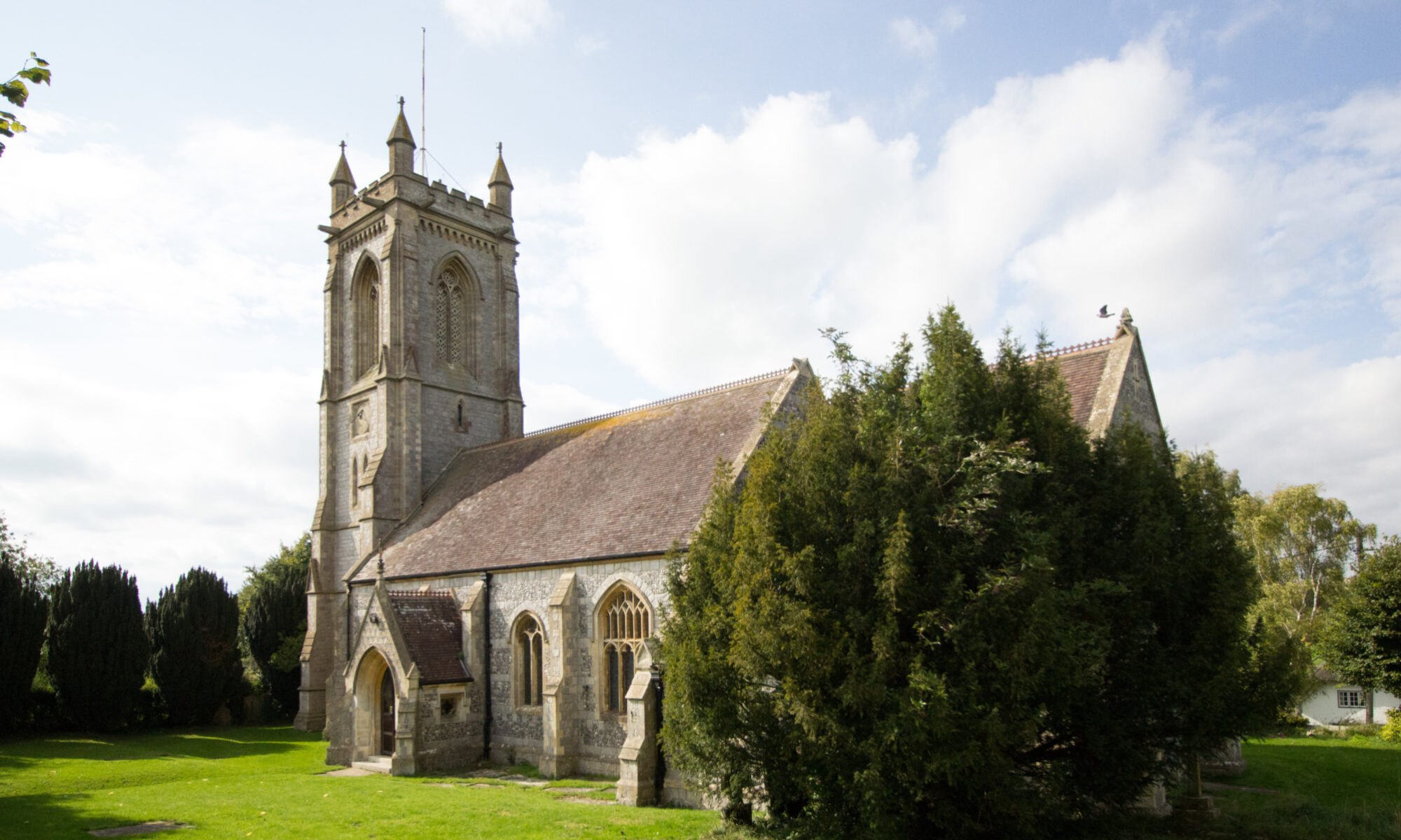
Watermeadows as seen from the tower of West Overton Church.
The river has been managed as a resource since at least the 10th century when there is a reference in the East Overton charter to a series of offtakes at Uferan Tun. These could have been for drainage but may have been an early form of irrigation.
The most intensive management of the river came with the construction of the water meadows, a feature of chalk streams all over Wiltshire. West Overton is one of the few places where they have not been destroyed and although fallen into decay they still bear witness to an agricultural innovation that enriched the county for several centuries. Before the advent of artificial fertilizers sheep were folded over the arable to dung the soil. The sheep carrying capacity of the land dictated the extent of arable. The number of sheep carried was limited in turn by the ‘hungry gap’ at the end of winter when the hay was used up and the spring growth had not yet begun. Water meadows were devised to bring on ‘early bite’ and close the gap. The springs that feed chalk streams maintain a consistent temperature of about 10 degrees C so meadows could be kept frost free by allowing water to flow over them. River water also carries nutrients which enrich the soil. Deposits of gravel below assist drainage.
There were water meadows along the whole length of the river through our parish and downstream beyond it. Brickwork from the various constructions can still be seen in many places but the ridge and furrow formation typical of bedwork meadows has largely disappeared except at West Overton and, in slanting light, at Fyfield.
The flow of the river had first to be dammed by the construction of weirs and hatches so the water level could be built up. From the resulting ponds a water carrier took water along the upper level of the meadow. The ridge and furrow beds ran parallel to each other and at right angles to the contour of the land and therefore to the water carrier. Water was released by way of sluices from the carrier to run along smaller channels cut into the crown of each bed. From here it overflowed down the sides, or panes, into the furrow and thence into a tail drain which returned it to the river.
Diagram much simplified.
 A single meadow system often continued beyond a single manor. It crossed tenurial boundaries. A drowner, or manager, could be responsible to several landowners. A mill could also be involved as at West Overton where the mill leat fed the main water carrier. Precise demarcation of rights and responsibilities was needed.
The flow to the meadows was kept up throughout the winter months when there were most nutrients in the water. Short drying out periods allowed the grass to ‘air’. The meadows were ready for grazing by mid March when the sheep were folded over them by day and returned to the fields by night. As many as 500 sheep would be crowded for one day onto an acre of meadow and would then fertilize an acre of arable overnight. The flocks were moved over the meadows in sequence. At the end of April the sheep would be taken off and the meadow drowned again for the hay crop to be started. The hay would be cut in June producing four times the yield of an ordinary field, regardless of rainfall. After the hay crop the meadow could be drowned once more before summer grazing by cattle, though sometimes a second hay crop was taken off. Heavy grazing continued until October when the now trampled meadows were repaired before the winter rains.
Between the 17th Century and the 19th Century the sheep kept were Wiltshire horn, now a rare breed. Neither fleece nor carcass was the primary consideration. These sheep were bred for walking. They also thrived on the rough grazing of the downs when not on the meadow.
Primitive systems of flooding and draining for increasing the fertility of the land were practiced from the late 16th Century. Surveys of the Earl of Pembroke’s manors show many references to water mead, wette mead, and wett ground in the early 17th Century and water meadows were well documented at his Ramsbury estate. It is likely that some form of ‘floating’ (i.e. initial construction) took place on his estate at Overton. The meadows we see now are of a much later date but they appear to be laid out over an earlier system. Floating required a huge capital outlay but the improved value was also immense.
There were many reasons for the decline of water meadows: the planting of root crops for winter fodder, the introduction of improved winter grass, the repeal of the corn laws, the drift to the cities of rural labour, but for over two centuries these systems, were one of the glories of our agriculture
A personal view in 2005 from Mary Spender
The Woods are set high (600ft) above the valley. Looking down to the North, we can see the villages nestling below; the A4 traffic is a moving strip in mid-horizon, and Fyfield Down stretches out almost bare in its patchwork of large open fields beyond. Natural folds in the Downs give a wonderful feeling of space without appearing as bleak, say, as the larger Downs to our West (towards Devizes) or further South in the County.
 Even on a misty morning, when we woodlanders are alone here, floating above huge white clouds with no sign of the human world, there is no feeling of isolation – only peace and rural beauty.
The approaches to the woods are all open fields, with byways and footpaths giving access, except for the eastern (Clatford) side along which runs the lane linking Clatford to the Marlborough/ Oare road. This lane has steep sheltered grazing all along the opposite side to the Woods, much beloved by small chilly lambs in early Spring.
The setting leads to glorious views as one walks or rides around and into the woods.
Within the 1200 acres of woods, there is a leafy enclosed feeling as one explores the various paths and rides well-maintained by Forest Enterprise (gumboots or walking boots are still necessary in the winter!). The bluebells in May are of course famous and attract hundreds of visitors, but every day the locals pass our property on foot or on horseback, young and old, with dogs, alone, with large families, on bikes – the woods are indeed well-loved.
Early in the morning or much later in the day, the deer come out to graze in the peace and the woodland birds sing their hearts out (keeping a wary eye open for the buzzards and sparrow hawks). By nightfall, the place is quiet except for the owls and the odd cry of a fox. The stars of course are fabulous.
Yes, the woods are a wonderful place to live: the peace and quiet is unbelievable (and can be unnerving to city-dwellers..) only broken by happy  shouts of visiting children or, not so pleasantly, by the chicken lorries grinding up to their farm here on the Lockeridge side. The views are beautiful through all the seasons, and there is a distinct feeling of timelessness and history: the Woods have been managed since the Bronze Age, and villagers first dwelt up here in the early Middle Ages.
The map below, kindly adapted by Nick Stedman from a map belonging to the Forestry Commission, shows the current outline of West Woods and all the names of the various woods, groves, copses, and grounds that go to make up its 1200 or so acres! Most are self-explanatory (Barrow Copse, Brick kiln Copse etc); some we know (Mr Pumphrey was the farmer/landowner who built the Manor farmhouse in West Overton where Michael and Priscilla Maude now live), some we don’t (Pickrudge ??).
I have copies of more Forestry maps if any one is interested, and I also have a copy of a species survey done some years ago and now held in the Wiltshire and Swindon Biological Records Centre. Please feel free to contact me if you would like to look at any of the information I have, or if indeed you can add to our knowledge. By the time you are reading this, the series of archaeological walks we have been advertising over our Parish may have taken place (w/e of August 5th/6th/7th): led by Professor Fowler, they will no doubt have explained a lot to us, and I for one am really looking forward to them.
Historical Background to the Woods
West Woods is thought to have hardly changed its boundaries in 4,000 years and people have been visiting here since before the Bronze Age. A good supply of flints had already tempted our Stone Age ancestors, and when more sophisticated tools/weapons were invented in the Bronze Age and then the Iron Age, West Woods provided excellent charcoal facilities. For more information on these early days, and also through the following centuries, consult The Victorian History (volume XI) and Peter Fowler’s “Lettice Sweetapple” and “Landscape Plotted and Pieced”. Gill Swanton’s article in the July magazine described the general history of our Parish.
Throughout this time, the Woods were well managed – yielding wood for the villagers’ needs, grazing for livestock, pannage for swine etc – but were also enjoyed: recreational hunting for rabbits, foxes and deer has always been popular.
By the mid 18th century, the estates of the Duke of Pembroke (Pickrudge and Pumphrey’s Wood and lands to the south) and of the Duke of Marlborough (lands to the north) owned the Woods. Good management continued – for example yielding hurdles, thatching spurs and faggots from the hazel – and aviaries flourished to provide pheasant shooting in the time of the Meux family in the late 19th century. “Cover” for these shoots could explain the “odd” rhododendron still to be seen.
More recent history shows the end of private ownership. The Olympic Agricultural Company bought the Woods, and most of the valley, in 1906. In 1914, their new Farm Manager was Frank Swanton. In 1928, they sold to a consortium of local businessmen who clear-felled the whole wood and then in 1931 sold 1008 acres on to the Forestry Commission who re-planted mainly with beech ( the original oak and hazel coppice can be seen on the edges, but beech still covers around 75%, with ash and sycamore, some conifers, red cedar and pine making up the rest).
Pickrudge and Pumphrey’s Wood, 179 acres, were sold privately in 1917 and  then sold on to the Forestry Commission in 1940.
Thus the Forestry Commission (now Forest Enterprise) have been in control for over 60 years now, and their Foresters have been part of the community: Bill Ayers was born here, in West Bailey, and David Giles still lives in Lockeridge. In earlier days, two Foresters lived in the two estate cottages beyond Breach House and the Ranger himself lived in Forest Lodge.
The Future
Written by our own Bill Ayers in 1996, the Forest Enterprise Design Plan for West Woods seeks to implement their now more sympathetic attitude to restoration of ancient woodlands: since about 1985, high density stocking is no longer pursued, and the impact of felling on the landscape is now seriously considered. The previous clear-felling policy is replaced by planned thinning (don’t worry, they know they mustn’t go too far and undermine the bluebells which so enjoy the close shade of the beech!).
Timber prices have been very low and objectives are no longer only to meet the requirement of the strategic timber reserve and to remain economically viable, but to grow more varied timber of good quality, to encourage recreation and to support national policies such as those covering our AONB (Area of Outstanding Natural Beauty) and the SNCI status (Site of Nature Conservation Importance) designated by the Wiltshire Wildlife Trust in 1984. All good news to us!
(with thanks to Fraser Bradbury and Bill Ayers of Forest Enterprise
I and my family came to the valley in late 1970, after one of the big factors that caused a very rapid decline in the wild bird population had already occurred. I refer to the severe winter of 1963-64 snow, freezing and icy winds lasted over two months and icy snow was still in some places until June. I think the worst hit wild bird was the Grey Partridge, thousands froze to death from starvation and until this day it is quite a rare sight to see a covey of Partridge. For many years, shooting and game syndicates refrained from shooting them.
The hedgerow birds suffered losses with the decline of the Shire Horse. Tractors took over most land work and as they got bigger and more powerful miles of hedgerows were ripped out to make fields bigger. Habitats of the Greenfinch, Bullfinch, Hedge Sparrow (or Dunnock), Linnet and Yellow Hammer to name a few were lost forever. Years ago every village and hamlet had their own roadman to keep country lane verges tidy. The majority of these men were nature lovers and very often if a patch of grass verge was left, you could guarantee that a Yellow Hammer or Meadow Pipit was nesting there. Then along came the tractor and mower to tidy the verges, so away went the nests of these birds that the old roadman would have preserved.
Dutch Elm Decease was another killer of the bird population. Most Elm trees had holes and loose bark, ideal nesting places for the Tree Creeper, their disappearance also aided the decline of the Tree Sparrow, Starling, Owls and to some extent Jackdaws.
Old barns and sheds that housed livestock during the winter have disappeared from the landscape and so Barn Owl numbers fell, the Stock Dove was another victim.
Game keepers were employed by landowners and shooting syndicates to look after the game birds, so they did not like birds of prey on their patch, they virtually had a licence to kill them. Nowadays with the new government laws making it an offence to kill birds of prey we have seen a significant increase in their population. Buzzards can now be seen every day in the Valley. The gamekeeper also controlled egg stealing birds, Jays, Carrion Crow and Magpie were not welcome on his patch. These three birds have increased over the last thirty odd years. So is this another reason why our songbird population has declined?
A new bird to the valley is the Red Kite, introduced to Savernake Forest in the late Nineties. It can now be seen on occasions hunting across our valley. A bird that made its own way into Wiltshire was the Collared Dove, breeding for the first time in Norfolk in 1952 it gradually spread across the country and arrived here in the late Sixties, now it is one of our most common birds.
A lot of fields in the valley are now ‘set-aside’, these are uncultivated and so may increase the nesting of Lapwing, Skylark, Corn Bunting and Meadow Pipit. Some landowners in conjunction with the RSPB are sowing wild plants to encourage these species. Other landowners are planting tree plantations and new hedgerows, this hopefully will help to increase the numbers of Yellow Hammer, Linnet, Bullfinch and Whitethroat. The banning of hedge cutting during the nesting season should also help, it is now an offence to destroy and disturb nesting birds in this way.
This valley of ours has a wide range of habitats. Woodlands support five of the British owls, along with birds of prey, Nightjar and Woodcock. Downland, fields and hedgerows as already mentioned. The river and meadow land have Duck, Coot, Moorhen, Little Grebe and Snipe and a few areas of reed bed for Reed Bunting, Reed Warbler, Sedge Warbler and Willow Warbler.
This changing face of bird life in the Valley is as I see it and is my own personal view – as a keen feeder of our feathered friends.
article by Derek Hartshorn